
Runkurakay: The Circular Tambo Watching Over the Inca Trail's Second Pass
Shortly after leaving Pacaymayo and resuming the climb, the Inca Trail 4 days reaches Runkurakay: a small but singular archaeological site that breaks from the rectangular architecture typical of the Incas thanks to its unmistakable circular shape. Along with Warmiwañusca and Phuyupatamarca, it's one of the three great landmarks marking the transitions of the trek.
What Is Runkurakay?
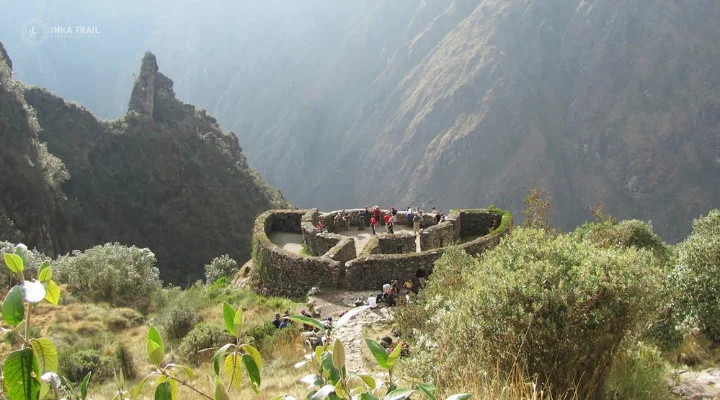
Runkurakay is a small Inca archaeological site that stands out immediately for its design: while most Inca buildings follow rectangular floor plans, the main structure here is oval and semicircular, almost basket-shaped. In fact, one of the most widespread interpretations of its Quechua name is precisely "basket shape," though alternative readings also exist, such as "abandoned house," "collapsed house," or "pile of ruins" — a reflection of the ambiguity common to many Quechua place names that have survived to the present day.
Runkurakay is believed to have functioned as a tambo — a waystation or resting point for chasquis, the Inca Empire's messengers, and official travelers moving along the Qhapaq Ñan network. Its exact function, however, hasn't been established with full certainty: some researchers also point to a possible use as a watch post, storage facility, or even a ceremonial space.
An Uncommon Architecture
The main structure at Runkurakay is entered through a passage 4.50 meters long by 2.20 meters wide, which leads to the interior chambers. Its walls feature niches, small alcoves, and trapezoidal doorways — characteristic elements of Inca construction, combined here with a floor plan that doesn't follow the usual pattern.
Some archaeologists suggest this circular shape may be directly linked to the site's role as a lookout: from here, both the Pacaymayo valley and the access to the next stretch of the route are visible, which would have made Runkurakay a natural control point within the Inca road system.
The Runkurakay Pass
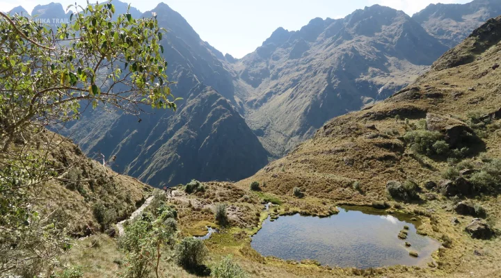
Very close to the archaeological site sits the Runkurakay pass, at 3,998 meters. It's the second of the three major passes crossed on the Inca Trail, and the lowest in elevation of the three, making it a somewhat less demanding climb than the previous day's Warmiwañusca. From the top of the pass, a view opens toward Yanacocha lagoon, a dark-colored body of water surrounded by puna grassland at around 3,800 meters — one of the least photographed but most peaceful landscapes on the entire route.
A Little-Visited Site That's Key to Understanding the Route
Runkurakay doesn't impress by size — it's considerably smaller than sites like Sayacmarca or Wiñaywayna — but it does by what it reveals: the Inca Trail wasn't just a scenic footpath, but an organized road network, with rest points, control posts, and communication stations strategically distributed to support the movement of people and messages across the empire. Understanding Runkurakay helps read the rest of the route with different eyes.
Climate and Surroundings
The climate in this stretch of the Inca Trail is notably variable, with temperatures ranging from around 23°C (73°F) during the day to near 0°C (32°F) at night or in foggy conditions. The surroundings combine panoramic views of the Urubamba valley with high puna vegetation, typical of this elevated section of the route.
Location and How to Get There
Runkurakay sits within the Machu Picchu Historic Sanctuary, at the convergence of the Urubamba and Aobamba valleys, about 13 km from the start of the classic Inca Trail. There's no vehicle access: it can only be visited on foot, as part of the morning of Day 3 of the trek, after leaving the Pacaymayo campsite.
Reference location of Runkurakay, Machu Picchu Historic Sanctuary, Cusco.
Other Stops Near Runkurakay
Pacaymayo
The highest-elevation campsite on the route, the starting point for the walk to Runkurakay.
Sayacmarca
The citadel known as "the inaccessible town," visited shortly after crossing the Runkurakay pass.
Phuyupatamarca
The trek's third major landmark, known as "the town above the clouds," visited in the afternoon of Day 3.
Discover Runkurakay on Your 4-Day Inca Trail Trek
Runkurakay is the gateway to the most archaeology-rich day of the Inca Trail. Check out the full itinerary, available dates, and everything included in our classic Inca Trail tour.